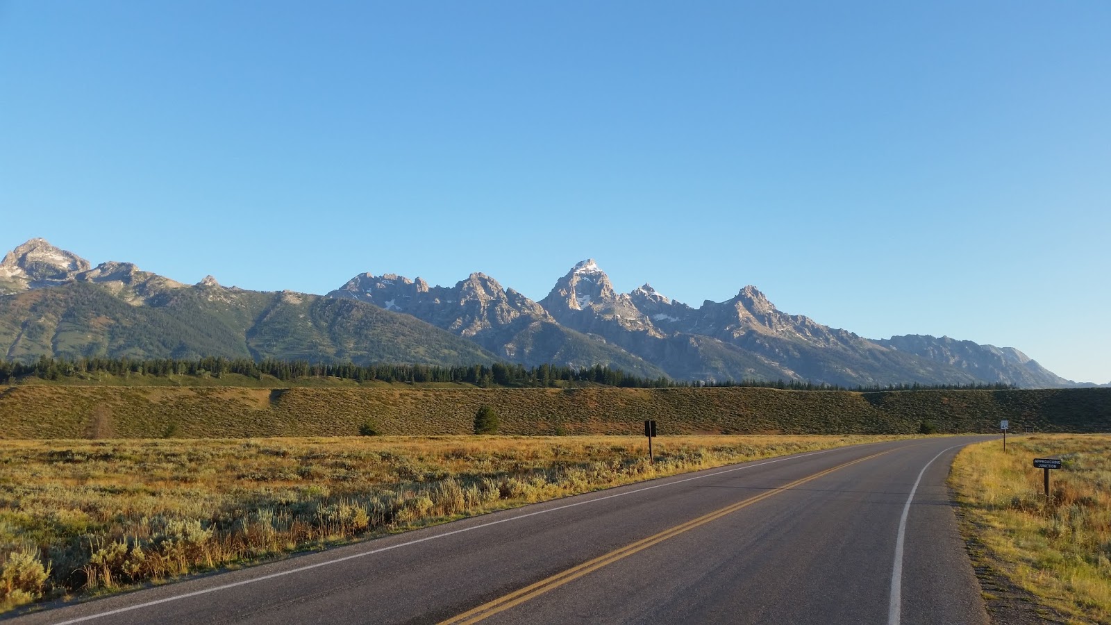
Thursday, August 13, 2015

A Tale of Two Runs Part 2

The second run was also a much needed run, but for different reasons.  After I had told my friends Misty, Debbie, and Jeremy about the Teton run, they wanted to go.  So we planned a small group run there for two weeks later.  The plan was to drive up Friday afternoon, sleep in the truck at the trailhead and hit the trail early Saturday morning, then drive back home Saturday night.
This looked like fun.  I’d get to hit the trails with some of my favorite people, enjoying it together.  Well, as the days progressed, the weather forecast deteriorated.  It was to the point where there were predictions of 1”-3” of snow above 10000’.  Yeah, I didn’t want to do that at all, and neither did anyone else.  So Thursday, Jeremy suggested that we head south and west to run the Ruby Mountains in Nevada.  I was all over that because running there has been on my running bucket list as well, probably for longer than the Tetons.
The Ruby Mountains are in east central Nevada, just south of Elko.  The mountains are part of the Ruby Crest Wilderness Area and there is a 34 mile north to south trail that traverses the length
We all agreed to do that run instead and went with the same plan, drive out to the trailhead Friday afternoon, sleep at the trailhead and hit it the next morning.
Thinking the weather would be much better, we were pretty shocked to get hit by a thunderstorm driving across the west Utah desert.  It rained so hard we had to slow down and pull over to the side of the freeway.  Wow!  Haven’t seen rain that hard in a very long time.  Eventually, it quit and we had calm for the rest of the way.  The forecast was calling for the skies to clear by Saturday morning.
We got to the trailhead just after dark, and apparently we weren’t the only ones with the same idea as there were quite a few cars in the lot, some with people in them, some empty.
The ladies crashed in the back of the truck while us guys slept on the ground. 
The girls slept well, us, not so much
The skies cleared some, and with no moon or city lights around, the stars were spectacular.  I went to sleep just staring at the sky.  I woke about 2am and realized I was getting wet.  It must have sprinkled some and the water soaked thru my bag, so into the cab of the truck I went.  Needless to say, I didn’t sleep too well after that.
Once daylight hit, we got up and got ready.  It was kind of a dreary, cloudy morning. 
Kind of a dreary start
Temp about 45, clouds at about 9500’ (we were at 8700”).  We knew we would be in the clouds during part of our run, we just didn’t know for how far or long.
I'm the one in safety orange
Even with the clouds, the scenery was breathtaking, huge trees, numerous lakes, huge cliffs.  After about 2 miles, we were definitely in the clouds and could see very little in the way of scenery.  Every once in a while they would thin and we could get a small glimpse of what lie out there.
Pretty obvious
We climbed pretty steadily for the first 3.5 miles, dropped down a bit, then made our way above treeline on the next climb. 
Now the conditions got somewhat bad.  Steady wind at about 20-30 mph and colder, wind chill definitely in the 30’s, not to mention that we had no idea of where we were going.  We could see the trail just fine, but that was it.  No scenery, nothing. 
Trying to find something to take a picture of
Couldn’t see more than about 100 yards at most.  Thank goodness it wasn’t raining.  We would have probably turned around had that started.  We did come across the occasional backpacker and to a person they all looked a bit miserable.  Chatting with a few we found out that the previous couple of nights on the trail had been epically bad weather.
Entering the wilderness area
Storms, rain, snow, hail, lightening.  Yeah, none of them were real happy.
So as we’re going along these ridges, the sun keeps trying to poke out.  It would get lighter, we could see faint shadows.  Finally a bit of blue sky poked thru and within about 15 minutes we had full sunshine.
Clearing off
The clouds just blew away.  The scenery that unfolded around and beneath us blew us away.  Huge mountains, some with snow still on them, huge glaciated valleys sweeping down to the desert floor, ranches 6000’ below.


Our original plan was to do an out and back, going to Overland Lake, about 18.8 miles out.  We decided to cut it a bit short and make the turnaround at 15 miles. 
Prayer flags?
Right at 15 miles, we found the perfect place to stop, eat, enjoy the views, warm up in the sun a bit and just enjoy where we were.

Eventually, we decided to begin the trek back, but now with the clouds not in our way and the wind dying down, we could really marvel at what we saw.  And marvel we did. 
Lunchtime
There were certain sections of the trail that we had been on in the morning and in the clouds that were now clear and were totally different than what I expected.  We saw crystal clear high alpine lakes, towering cliffs and peaks, wide open meadows.  Who knew that something like this existed in east central Nevada.  What a hidden gem.


Lamoille Lake

Liberty Lake
The run back took about the same amount of time, but it felt faster.  We did finally have to fill up on water.  We just dipped out of Liberty Lake, one of the clearest lakes I have seen in a long time.  We didn’t see much in the way of wildlife, heard and saw lots of birds, including hummingbirds, saw one mountain goat, a good sized buck.
The end is near
We finally got back to the trailhead, well before dark and cleaned up a bit before heading out.  We did stop in Elko for dinner and then made the long drive home.
A last look 
So why was this run much needed?  I got a chance to run with a few close friends.  We got to share a run in a phenomenal part of the country, share a bit of adversity, shared a lot of jokes and good times, and did some bonding while doing something we all love.

When you do a couple of runs like I did, epic, beautiful, difficult, fulfilling, then come back to civilization, the job seems a bit mundane.  I have that urge to get out and do something like that again, either with friends or by myself.  Doing stuff like that just makes you feel much more alive, connected with yourself and nature.  We’re out there doing things and seeing things that very few people will ever get to see or do.  There’s something magical about that and I look forward to the next running adventure I have.

A Tale of Two Runs, Part 1

Like many of you that run trails, run ultras, just run a lot, I get asked why by non-runners.  “I don’t even like to drive that far” seems to be a standard response.  If I had a nickel…..
Well, in the past three weeks I have had the opportunity to tick off two of the epic adventure runs that were on my running bucket list.  Both were about the same distance, 30-35 miles.  Both took about the same amount of time, roughly 10-12 hours.  So I certainly wasn’t going for speed.  Both opportunities popped up quickly and I had to jump on them in fairly short order.  Both runs were just what I needed at the time, but for completely different reasons.  Runs like this, and the ability to do them, are one of the big reasons I run.  So here they are.  Warning, this may get to be a long and tedious post.

Teton Circumnavigation

This run has been on my list for a few years.  I have seen a few pics, chatted with a couple of people that have done it and I knew I had to do it one day.  It was hard to try and get a few friends together for this one.  Since Karen and I were going to be rafting on the Snake River with her work trip, I thought this may be the one opportunity I have to go.  I asked my lovely wife and she gave me the ok to go for it.  She was a bit nervous since I would be in some pretty remote backcountry by myself, plus bears, big grizzly bears.  I was a bit nervous as well.  Going out this remote by myself is something I don’t do very often, and I’m kind of a worst case scenario guy, but I thought stepping outside my comfort one wasn’t a bad thing.  I knew I could cover the distance, not an issue at all.  My big concern was bears (bear spray), and affecting a self-rescue if needed.  I knew that I would probably see backpackers on a regular basis while out.  For gear, I took the bare minimum I thought I would need if I had to spend the night.  Plenty of calories, matches and a candle in a baggy, rain shell, space blanket, headlamp, gloves, beanie, extra dry shirt.  Water?  Not an issue.  I knew there would be plenty of sources.

Looking forward to this
Route –

I started at the Lupine Meadows trailhead.  My plan was to run the Valley trail south to Death Canyon, then head up into the mountains.  These first 7-8 miles were filled with running past beautiful lakes, quiet trails, lots of wet foliage, and a nice easy pace.  If I felt like walking, I did.  The sun was just rising and casting its light through the trees, and I was in my happy place.  I’m trotting along, smile on my face, when Bam! I trip over a root and go down.  As I typically do, I rolled to a stop.  As I got up, some sort of stinging insect decided my ear was an inviting target and nailed me.  Still, nothing more than a bit of dirt on my legs and hands and I was good.  I carried on, still smiling.  After a couple of hours, I came to Phelps Lake.  J
Death Canyon
As I started up Death Canyon, I came across a few other day hikers out.  To this point I hadn’t seen a soul, and it was wonderful.  As I climbed up the trail into Death Canyon, I marveled at how much water was coming down.  The roar was almost deafening.  Up and up I went, eventually making it to a flatter area where there was an old log ranger cabin.  Tucked back in a quiet area, under some trees.  How idyllic.  Now some serious climbing began.  I found the Alaska Basin trail and started up that.  I knew that I had about 2000’ of climbing in just a couple of miles, so it was going to be a stout one. 
As I climbed up, the views got more and more expansive.  I started seeing peaks around me, I was able to really look out over the valley below.  I encountered a couple of other runners.  They had started at Jennie Lake and were going down to Phelps Lake.  We chatted for a minute and they were on their way.  I saw the occasional backpacker heading back down after spending some time in the backcountry.  I caught up to some other day hikers that were going up Static Peak.  So I wasn’t as alone as I thought I would be.  Still, just being out by myself with my thoughts was really nice.  All I can hear are the voices in my head.
The view from Static Peak Divide.  Phelps Lake below
I stopped at Static Peak divide for a bite to eat and to just admire the view of the Teton Valley.  I finally got up and headed down the other side.  I came around a corner and was stopped by the view of the Alaska Basin.  Huge, empty, seemingly barren, and beautiful.  As I traversed along the side of a mountain, I just kept stopping to take it all in.  This was stuff I had never seen before, and it.was.awesome.  As I came around another point, there was another section of the basin, even bigger.  I stopped again just to look.  This was a recurring theme, lots of stops to just look, take pictures, just enjoy the solitude.  Of course trying to trot along for a sustained amount of time at 10,000’ means getting out of breath quickly, so I had an excuse to stop.
First view of Alaska Basin
As I ran/hiked along, I did pass the occasional backpacker, usually a couple of people an hour, so I was never truly isolated.  Alone?  Yes.  It was wonderful. 
I went past numerous small streams coming off snow fields, crossed several stubborn patches of snow still covering the trail, stared in wonder up at the peaks that surrounded me.  I was definitely in my happy place. 
This run was truly good for my soul and I was enjoying the hell out of the day.
Eventually, I started up the last climb to Hurricane Pass.  I knew that after that, it was all downhill back to the Teton Valley.  As I went uphill, I noticed Grand Teton starting to peak above the ground. 
Grand Teton in your face
When I reached the top of the pass, that peak was in my face.  From the valley floor, you can see Grand Teton some 6500’ above and several miles away, and it looks pretty big.  Now Grand Teton was only 2000’ above me and the top was about 2 miles away as the crow flies, yeah, in my face.  As I looked down where the trail led, I saw the Schoolroom glacier.
Schoolroom Glacier
I would be running past that, how cool.  I had never been near a glacier before (I lead a sheltered life), so I had to go over and stare at that for a while.  So much to look at, so much fun.
Now I had 9 miles of trail to run down Cascade Canyon. 
Looking down into Cascade Canyon from Hurricane Pass
I knew that I would encounter many more people along this trail, hikers and backpackers, day tourists out for their little strolls.  What I wasn’t prepared for was the scenery.  The shear amount of water cascading off the mountainside from glaciers and snowfields. 
Roaring so loud it was almost deafening.  So many times I wanted to just stick my face in the water and drink, so I did.  Cold, clear and so good.
The closer I got to Jenny Lake at the bottom of the canyon, the more people I saw.  Sigh!  My alone time was done.  Eventually, I ended up running along the trail beside Jenny Lake and back to the truck.  One encounter with some tourists really stuck with me here.  I turned off on the Moose Lake trail and came across a family.  They stopped me to ask if there were moose along here because the guidebook said there should be.  I looked out over the lake and surrounding marshes and said “well, it looks like perfect moose habitat, but I don’t see any”.  They looked disappointed and headed back to their car.  If they had gone another 100 yards down that trail and just looked at the world around them rather than the guidebook, they would have seen evidence of recent beaver activity, deer tracks, a snake, all sorts of stuff.  I really found it kind of sad for them.  All this wonder around them and they were focused on seeing a moose because some book said it would be there.  Another sigh!
Anyway, made it back to the truck right at the 12 hour mark, so yeah, pretty dang slow, but pretty dang amazing.
I finished off my adventure with pizza and beer while watching the sunset over the Tetons.

Overall, it was a perfect day of running.  Like I mentioned earlier, it fed my soul.  The beauty, the solitude, the grandeur.  I needed this run.

Tuesday, July 21, 2015

The Age of Aquarius, or the Capitol Reef 50 mile

Prologue

Capitol Reef is a national park located in central Utah.  The race was not run in the park, but rather on the Aquarius Plateau/Boulder Mountain.  This plateau is west of the park and the views from the rim allow you to see down into the park some 7,000’ below.  Capitol Reef is a bit more recognizable than Aquarius Plateau.
There are worse race HQ's
The Aquarius Plateau is the highest plateau in the country, with much of it being above 11,000’.  We would be running along the Great Western Trail for much of the race, as well as some ATV roads.
Not sure where to start with this report.  A lot has already been written and talked about regarding this race, so anything I add will be largely a repeat of what others have said.  Here's a short video I found.
This was a tough race for reasons that one normally doesn’t associate with a tough race.  There weren’t huge steep climbs, no quad crushing descents, at least not long ones.  Much of the course was essentially flat.  What made this course difficult were two factors, the terrain and the altitude.  Try “running” for 20 miles at, or above, 10,000’.  Spend 18 of those miles above 10,500’.  Now factor in some other items.  All of the rocks that we dealt with, route finding, overgrown brush, widely spaced trail markings made for a slower than anticipated run.  Most of the time, my “running” wasn’t much more than to shuffle a bit faster than a walk.  Keep in mind that all of these difficulties are pluses in my book.  I may not think so at the time, but they really are.
I had originally signed up for the 100 mile distance, but the week before the race rethought that idea.  I figured that if I ran the 100 mile, it would take at least three weeks to recover and get back into some serious training for Wasatch.  Since Wasatch is my key race for the year, I didn’t want to lose those three weeks.  A 50 mile race would mean that I could take a few days off and go easy before hitting the training hard again.  Looking back, it was a wise decision.  Keeping my eye on the prize.
I knew that this race would be hard.  I tend to not do too well at high altitude.  I don’t get altitude sickness or anything like that, I just slow down a lot and occasionally get some slight exercise induced asthma going.  I also knew that if I could do reasonably well here, that running at altitude during Wasatch wouldn’t be an issue at all.

Race Time

The race started about 30 minutes late due to a slow bus ride to the start.  Gorgeous morning, temps in the upper 40’s, some clouds, but generally sunshine.  We started climbing right out of the gate, but for the most part, the initial miles to the first aid station were runnable, even uphill. 
The initial miles
The course was amazing from the start.  We would be running through trees, then all of the sudden be running in a huge green meadow.  I loved it.  Huge aspens, fir, pine.
The first aid station was at around 8.5 miles.  By then we had climbed roughly 1500’, not too bad over 8+ miles.  However, shortly after leaving that aid station we had the one monster climb of the race.  A “road” had been cut into the side of the plateau.  We gained 1000’ in a mile.  Not huge, but enough to make you wish it was done as soon as possible.  I found out later that this is a “road” used to drive cattle up and down the plateau for grazing.
Cattle "road", yep that's me.  Photo: Dee McLaughlin
Add caption
Once up on the plateau we followed along the east rim for the next 10 miles.  In a word, the views were stunning.  We could see into the national park some 20 miles away and 6000’ lower.  We could see the Henry Mountains.  One of the most remote mountain ranges in the country (at least the lower 48).  This was “big” empty country.
Pretty high up for a long time
The second aid station was at 16.5 miles.  This aid station was in the middle of nowhere.  Smack in the middle of a meadow at 11,000’.  It took them two hours to get there from the start.  After the second aid, we kept along the rim for a bit more, then headed for the interior of the plateau.  This meant a bit of climbing.  Not much, but going from 10,800’ to 11,100’ can be significant.  Lots of high alpine meadows, small lakes, streams.  Who knew something like this was in southern Utah?
The third aid station came around at about 21 miles and some familiar faces were present.  Kelly and Jo Agnew were running the show there.  It was nice to chat for a few minutes with them then head on out and across yet another meadow.
Aid #2 in the middle of nowhere
The next aid station came at about 31 miles.  This was the longest section between aid.  By this time we had dropped down to 10,000’, running down through a canyon off the side of the plateau.  What a difference 1000’ can make.  Coming down the canyon the trail became more technical.  This was to be the story for the next 15 miles or so.  Lots of rocks on the trail interspersed with small sections of ATV road.
Miles 31 to 37 were reasonably nice trail.  Still very rocky, but easy to follow, well traveled.  The last bit into Donkey reservoir was on some dirt road.  After all of the technical trail, it was kind of nice to hit some easy running.
The section from Donkey to Government Creek took runners through a section of forest that had seen a forest fire.  Not the most scenic section, but interesting.  With the forest canopy now non-existent, the underbrush went wild.  This section was way overgrown.  At times you really had to push through the undergrowth and could barely see the trail.  Made for some slow going through here.  Oh, and the mosquitos were horrendous.  I was so glad that I had put bug spray in my drop bags, and used it.
The Government Creek aid was the last aid before the finish.  Only six miles to go.  It was in this section that I caught up to a couple of the last 50K runners.  When I finally got to Government Creek, I knew that we had significant downhill the last six miles.  I didn’t know that the remaining miles were all on dirt road or ATV trail.  Nice if you have any legs left to open it up.
It was interesting running those last six miles, descending through various climate and geologic zones, starting out in an alpine setting and volcanic rock and within a few miles dropping into a red rock/desert sandstone landscape.
At long last, I came to the highway, crossed it and ran the last couple hundred yards to the finish.  I was pretty glad to be done, it had been a very long hard day.

Aftermath

So, after 13 hours and 40 minutes, I finished.  I met Christian Johnson at the finish and asked if he had another one of those beers he was holding.  As he went off to get one, Jo Agnew came up and handed me a PBR.  Yep, two fisted it and they tasted really good.
So what did I think of this first year event?  I really enjoyed it.  It was much more difficult than I had imagined.  It was also way more scenic than I had thought it would be.  The scenery at this race ranks right up there with Matt’s Bryce race.  I took about 60 pictures and could have taken many more.  We ran past numerous lakes, crossed a bunch of creeks, saw some cool waterfalls.  I was surprised at how much water was up there.
Waterfall off the rim in the distance
The race was different in many ways from other races I have run.  First, much of this race was on a section of the Great Western Trail.  Given the condition of the trail, my guess is that that trail saw more use Saturday than it typically does in a couple of years.  Much of the time the trail was not a well defined path.  Rather, we had to look for the ribbons that were put out, rock cairns, and tree blazes.  I found myself always looking ahead for the next blaze/cairn/ribbon.  There were a few times when I had to stop and scan left and right as well as ahead in order to locate the next marker.  I never got off trail, but there were a few that did.  You definitely had to be aware of your surroundings.  That’s one of the things I liked about the race, having to really pay attention to where you’re going.
Any personal revelations from this race?  I didn’t “find” myself out there because I was never “lost”.  Nope, it was just another good time beating myself up for 50 miles.  Mentally I was good all day, never really had any down spots.  The short little climbs towards the end of the race got kind of old after a while, but you just do them knowing they won’t last long.
One of the other things I really liked about this race is the small entry field.  With the exception of the couple of 50K runners on the trail and the last two aid stations, I ran over 20 miles by myself, no other person was even close.  No one caught up to me, I didn’t catch up to anyone.  I like that.  I like to run with people during training, but on race day I typically like to run by myself.  Running with someone during a race means that either they are running your pace or you are running theirs.  I want to run my own race. 
Were there any downsides to this race?  Only one that I could think of, and it was minor.  The course marking could have been better.  I never had any problem following, but getting off trail and lost on that plateau could be serious.
So, would I go run this race again?  Yep, I’m already thinking about next year.  I want to see if I can drop my time significantly.  Would I recommend this race?  Absolutely, Matt does a great job with any event he puts on and this one was no different.  Go sign up and run it next year.

Restaurant review


Well, this really isn’t a restaurant review, but Matt had a “build your own” pizza bar at the finish.  It was pretty good, plenty of fixings from cheese to pepperoni to mushrooms to various veggies.  Good stuff.

More Pretty Pictures


The obligatory selfie 


The next aid station is down by that lake